

Earth Sight
Earth Sight | Track Pollution from Space
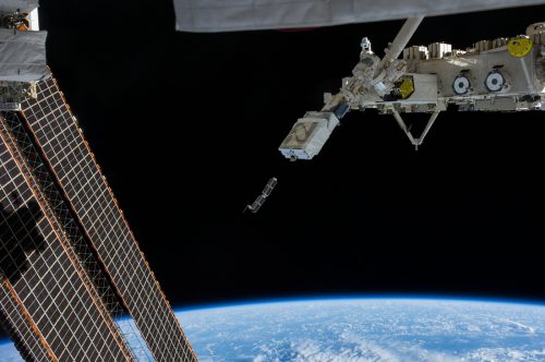
There are thousands of satellite “birds” up there. Buzzing around at all hours of the day and night – whether commercial, military, or educational – these satellites send and receive stat from professional and amateur ground stations around the globe.
– Charles Hamilton, Rodolfo Giometti, Richard Grimmett ‘BeagleBone’
A Larger Focus
Rubbishly gave me an excellent starting point for thinking about the problem of identifying and tracking pollution (within certain identifiable forms – ie rubbish and large particulate matter) in the ecosystem / public lands. It relies on customer / user inputs to build a map of rubbish across locations anywhere in the world where a person with a smartphone (& internet connection) can roam.
But therein lies multiple problems.
If Rubbishly relies on a large and continuous user base to really begin to map out rubbish / pollution / dumping, then there will have to be a large assignment of funds directly on marketing and community upkeep to ensure Rubbishly is used by and ever growing user base.
Issues of whether to monetise the app may come into play. After all, Developing & running an app like this will ultimately have to be funded in one way or another.
Rubbishly may have some use in areas which are more commonly trekked by urban populations / travellers who are interested in anti-pollution impacts. However, Rubbishly will have to keep working to maintain user engagement and to grow it’s user base.
What about ALL the areas of the Earth not really seen daily by people? What if changes in zoning, politics and ownership render some areas suddenly out-of-bounds for foot travellers? How can we ensure that areas tagged as polluted with rubbish are either ‘checked as cleaned’ and maintained as cleaned in areas where we haven’t build waste management partnerships?
How much effort daily will it take to build and maintain waste management and council / government partnerships?
Can there be a more efficient way in which to either streamline or replace some of these steps altogether? And how can we scale this to reach across the entirety of the Earth’s land surface?
Is there another way to look at this problem?
Anti-Pollution | A planetary Impact
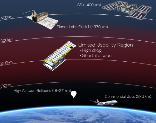
Large and sophisticated remote sensing satellites by Spot Image, GeoEye, and the like, are being challenged by small satellite constellation such as Planet Labs and Terra Bella that are deploying quite small but capable satellites.
– Ram S. Jakhu, Joseph N. Pelton ‘Global Space Governance: An International Study’
In the middle of Rubbishly development, I had a few brainwaves.
I contacted a friend who works with space, satellite and ML companies across America.
I learned that it would take a large amount of nontrivial image processing on them to be sure you’ve found rubbish, and you won’t be able to see it unless it’s dense enough. That said, this is an application we talked about pretty often. Also there’s not a lot of ocean coverage right now (but coastlines are covered well).
The satellites which Planet has (Dove, Flock micro satellites, which cover the whole land masses of Earth once a day – with a resolution of ~3m per pixel, could theoretically spot rubbish from space.
Creating an Organisation to Leverage Satellite Technology for Global Anti-Pollution Measures | From Rubbishly to Earth Sight
Earth Sight leverages satellite mapping technology for rubbish and pollution identification and tracking. Helping to make a cleaner Earth.
Earth Sight’s Vision is to Turn Big Data and Machine Learning into Action for our Partners and the Ecosystem
I thought, if you had a rubbish tracking app, it would be dependent on a large number of people using the app and platform, to gather enough points to show rubbish distributions in areas.
I thought, there has to be a larger scale solution to this, one which is not necessary reliant on the popularity (which waxes and wanes) of using an app, and of the limited scope of what people see on the ground.
Can we use both of these projects either in tandem – or do we seek to find which one is best to focus on and then give all our time and energy to the one which makes the most positive and useful difference in a smaller amount of time.
How Earth Sight Works + Process
Process | A Project Outline
On choosing a project in conjunction with an organisational partnership and goals of what to track and for what purpose, the following process is initiated: –
- A geographic area is chosen and the element which wishes to be tracked is noted (ie. rubbish, rate of deforestation) and an agreement is made as to what this looks like and how it should be measured.
- Continuous (once daily) images of set locations of flagged interest are fed to Earth Sight using the Planet API for image searching and change tracking.
- Earth Sight checks these images for varying degrees of change within the agreed upon parameters.
- These changes are then identified and tracked in the Earth Sight client API / Database.
- Reports are generated monthly for the use of the organisations involved for use in their own research and tracking cases.
This means that the satellite crosses a given location on the Earth at the same local time each revisit, which is useful for Earth science observations, weather monitoring, and military.
– Malcolm Macdonald, Viorel Badescu ‘The International Handbook of Space Technology’
Use Cases
In creating a viable first use case; examples can include illegal logging tracking in QLD, Australia, to rubbish dump / illegal dump tracking in areas such as Nairobi (eWaste dumps), Africa. In this case, deforestation / illegal logging tracking in Australia can be used.
- Deforestation tracking in a given geological location – and partnering with local organisations who are interested in tracking and identifying deforestation within given areas. For example, registering as a NFP organisation, and presenting a use case for the Australian Conservation Fund (ACF), who’s interest includes tracking illegal & unchecked deforestation in QLD and TAS states of Australia. Using this reporting to send information and details to the correct governing bodies and state representatives
The issues are not really ‘problems’ which are insurmountable. They are more about deciding ‘how’ to do the process. The set-up and the way in which we are deciding to tackle the issues. For example, Earth Sight could set up as a not-for-profit to do the initial base-line studies / volunteer work (manual pollution tracking using Planet Labs daily imaging
Partnerships + Assessing Value Proposition
PARTNERSHIPS WITH ORGANISATIONS + UNIVERSITIES
Partnerships also bring into consideration a network of eyes and organisations looking forward to this process and working on this problem. It’s far more efficient in tackling a problem, and does more to ensure a global scale of effort is achieved.
ASSESSMENT + ANALYSIS OF SATELLITE IMAGERY
But the assessment and analysis of images would be the hardest. It would require the manual labour of volunteers, who may have to be going through thousands upon thousands of images on a daily basis to be assessing the incremental or large scale changes made by deforestation – and to track the changes, according to the coordinate data – to begin to see at what rates the land clearing was occurring and to help to determine just who was clearing the land, to begin to associate these factors together and to build a case for the watchdog organisations in parliament.
This is a slow, ongoing and laborious project. It could be used with students of universities working on environmental issues, or new technology problem solving – so a marriage of both environmental studies and technology disciplines.
COMMERCIAL APPLICATION
Many companies (such as Orbital Insight “using geospatial analytics”) are using the analysis component of continuous satellite imaging of the Earth’s surface for commercial purposes eg. international comomodity analysis. This involves purchasing imagery from the companies which own the satellites (eg Planet) and developing the machine learning capabilities of image recognition in in-house developed AI systems, handled by teams of Computer Scientists. Once developed to this point, these companies can sell their services for commercial purposes at a high rate of return. Examples include assessing agricultural productivity (soil erosion, crop viability), economic testing (fuel stockpiling by competing countries / organisations) and seasonal fluctuations in customer use (customer car park monitoring).
Machine Learning Application | A Whole New Business
However, if this was to occur over a long period of time, then it would ultimately be best to create a computer science arm where appropriate machine learning (deep learning for imagery) would be harnessed in the following rough steps: 1) Learn what trees are. 2) Begin to identify trees and not-trees (empty / denuded land) 3) Begin to track the rates at which these trees disappear or not in continuos sets of location coordinates over time. 4) Use this data to visualise the rate of deforestation, where it is occurring and to allow researchers to further establish what / who are the cause of this deforestation – and the patterns of this occurrence.
A use case for ML + satellite application: –
- Teaching ML to see rubbish from satellite data.
This would have to start from the basics. 1) Find a place you know there is a lot of rubbish around and look at pictures of that to see whether you can tell. An example could be looking at the giant e-waste rubbish dumps in Ethiopia & other African countries. Maybe start small by identifying open air dumps (even legal ones in 1st world countries) & then starting image definition practices on those? Also have ground/field researchers to confirm the image overlay?
By getting images of areas you already know have a lot of waste and using those to work out how to find new areas based on the imagery. You could you start manually identifying rubbish within a certain amount of error, and use this (very long) process with a lot of data over several instances to teach advance scripting/ML to at least support the identification process? Theoretically of course – and possibly even teach local technicians how to identify rubbish / dumping? Like QA tech roles?
Machine Learning requires a LOT of data.
Possible Next Steps
In keeping with the altruistic side of this project – The next steps for this would be the following: –
- Raise some funding
- Talk to Planet Labs about getting the relevant data in a nonprofit situation
- Talk to someone like Orbital Insights about whether the exact problem you’re working on is already solved or what steps are involved with automating the detection. and/or
- Get volunteers to look at Planet images and try to identify dumping.
- My friend also noted that drone surveys (wouldn’t be particularly expensive and might be able to find more information closer to the ground and in areas not easily seen by the satellites. This could also be used alongside satellites as a tandem / addition step in the process.)
Final Assessment
This has been a fascinating conclusion to an amazing project and the direction it has taken me from my initial plan of picking up rubbish (which became the Rubbishly App concept) to the development of the Earth Sight project. Earth Sight itself showed a long and challenging road to developing ML which can ‘read’ rubbish / visible pollution and begin to identify it and track it using daily earth spanning satellite ‘flocks’ such as the satellites offered by companies such as Planet.
All in all, I would say that my thought experiment has taken me further than I had initially expected. It has also laid out a course which relies on Baysean thinking, of which I am proud of in terms of applicable uses. However, as I am not a Computer Scientist, nor am I building any competitive teams and/or business to rival this already heavily competitve industry, I would be deterred to take this concept further. Nonetheless, it’s been an enjoyable thought experiment with real-world applications – which, with the right teams of people and a healthy amount of luck and openness to opportunities, would create a very interesting company / not-for-profit.
I would assess the value of such an organisation as quite high, with numerous applications – but with the central theme of anti-pollution and pollution tracking – it would be something of high value and applicable use. This use would most certainly be of use in terms of global anti-pollution initiatives and partnerships.
Conclusion
The satellite and space industries are ramping up on levels of competition and serious responses to pressing problems such as tracking pollution, soil erosion and other wasteful practices on the surface of the Earth. As the satellite and machine learning / visual analysis industries continue to grow and secure funding, this will become even more mainstream, to the point of being able to pinpoint polluting industry and habits, right to its very source. And from that point, real change can then be advocated, legislated for and enforced.
* Update 15th September 2018
The State of California, USA has made the quantum leap decision to get their own pollution tracking satellite (or namely, use of the Flock satellite planet wide network) in partnership with Planet – which is a wonderful and meaningful breakthrough in the field of pollution tracking. This further validates the Earth Sight concept as sets precedence for satellite pollution tracking use on a government scale.
